Search

UWI in Society

Forecasting the Eruptions

Petroleum Geoscience engineers use innovative monitoring techniques and equipment to warn Piparo residents of volcano risk

By Serah Acham

When the Piparo Mud Volcano erupted on February 22, 1997, spewing mud and debris 200 feet in the air and covering an area of 2.5 km2, no one expected it. The villagers, many who grew up playing next to the then small, practically flat structure, were used to its rumbling and bubbling and had no sense of the danger that lay beneath. Today, all too aware of the risk in their backyards, they are reassured by the support of UWI St Augustine Faculty of Engineering’s Dr Oshaine Blake, PhD student, Kerneese Ramjarrie, and their team of fellow researchers, working hard to predict the next eruption.

The effects of the mud volcano are easy to see, from the high bulges that make a rollercoaster of the road into the village to the long cracks running through the driveway of residents, Shamshadeen Hosein— called Mr Shams—and his wife. And because the volcano is still very active, it continues to leave its mark. Mrs Hosein points out the shattered tiles at the front of their property, fragments so small it looks like someone took a hammer to them. That’s a recent development, she says.

Mr Shams shares that the frequency of the noises coming from the volcano even prompted him to call Kerneese. Though he and his wife have grown used to the gunshot-like sounds the volcano spits out in the dry season and the bubbling of the rainy season, this is different. “You might hear it,” he tells me as we chat around the table in his driveway during my visit to Piparo with Dr Blake and Kerneese in March.

The researchers want to check the results of the pressure and temperature gauges they’ve installed in the volcano, an innovative, first-of-its-kind technique meant to help them with their predictions, and I’ve tagged along.

Dr Blake, Senior Lecturer with the Department of Chemical Engineering’s Petroleum Geoscience Unit, says the noises are a good thing. Gas is being released, rather than building up and overburdening the volcanic system, which is exactly what causes an eruption. He is also quick to clear up: the land changes that we’re seeing aren’t only due to the volcano. There’s also active faulting in the area.

Dr Blake never set out to study volcanology. Jamaica-born and raised, he knew nothing of mud volcanoes before encountering the one at Piparo on a site visit in 2016.

In search of a simple, flat site to conduct seismic field work exercises with his students, he sought a recommendation from his colleague, Dr Ryan Ramsook. This led him to the Piparo Mud Volcano.

“I was fascinated. What’s going on beneath the surface?” he wanted to know.

'What’s going on beneath the surface?'

Dr Blake set out to understand as much about the volcano as he could. He and his students experimented with different imaging techniques until they found one that could show them its subsurface clearly.

Having learnt that Trinidad is home to many more mud volcanoes—32 onshore and more than we know offshore, some of which are active and some newly formed—and that the existing data on these phenomena is outdated, he realised this undertaking could have value beyond teaching.

“Trinidad is a small island, and a lot of people live right next to the mud volcanoes,” he says. “It's just a matter of time before we get [another] big eruption.”

Wanting to do his part to prevent this, with the help of Dr Ramsook, he decided to use his research, as well as modern equipment, to advance our knowledge and update our literature. Together, the colleagues also came up with the idea of a mud volcano research unit that would be responsible for monitoring all Trinidad’s mud volcanoes and other seismic events. They spent almost a year developing the research proposal and applied for funding through the ODPM. Now, almost six years later, they’re still waiting.

After an eruption at Piparo in September 2019, however, the entity did get involved, providing support in other ways.

Miss Mud Volcano

That year also brought Kerneese to the team. A PhD student studying the volcanoes under Dr Blake’s guidance, her goal is to become our nation’s expert.

“I want to be known as Miss Mud Volcano,” she says, sharing that she has always been fascinated by natural phenomena. When Dr Blake presented her with the opportunity to join his team, she was all in.

She explains that Trinidad is the only Caribbean island with confirmed, active onshore mud volcanoes, being uniquely positioned “at a tectonic crossroads, where different types of plate movements...occur”. Add the approximately 2.5 billion standard cubic feet of gas produced underground each day, and we have the perfect “over-pressurised” conditions for mud volcanoes to form.

She puts it into perspective. Many mud volcanoes are found near our oil and gas fields. Unfortunately, these areas are also home to many people.

The Piparo 1997 eruption illustrated the dangers that the volcanoes pose: over 300 people evacuated, 31 families displaced, pets and livestock killed, not to mention the damage to properties and vehicles. Some are still very active—Piparo’s and Devil’s Woodyard, most prominently—but new vents are being formed as well, like the volcano at Cascadoux Trace in Mayaro which erupted just last year, causing two families to evacuate their homes.

Dr Blake firmly believes that their research and the mud volcano research unit—which he is confident can still be formed—will help mitigate the risks these volcanoes pose to the public. Mitigating the risk to the public

Ultimately, that’s the big goal, Kerneese says. Right now, they’re trying to understand the system “given that it's so dynamic and changes every day”.

They’ve implemented monitoring techniques and set up equipment to detect surface and subsurface changes.

“There will be movement,” she explains, and if it’s headed toward people’s homes, they need to know.

The first technique the team employed was electrical resistivity tomography (ERT), “like an x-ray of the earth”, that allows them to see subsurface structures. What they found was, in her words, “pretty cool”. It was a pressurised mud fluid reservoir—a big pocket of mud and water trapped under high pressure beneath the earth’s surface. “We were able to see where, potentially, it's moving”, its shape, size and the extent it covered, and could even simulate the volume of fluid it contained.

They also use GPS monitoring to track ground movement changes. She recalls an earthquake that took place late last year. Faults shifted and fractures opened wider. “[That] could prompt activity at the volcano.”

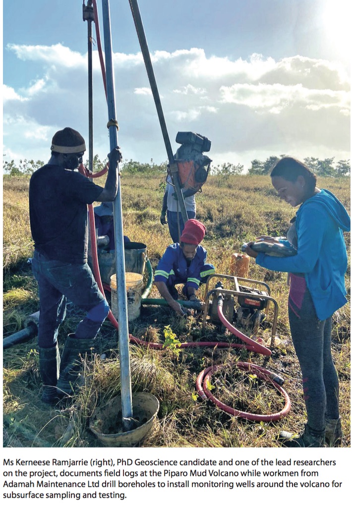
Other techniques include 3D LiDAR drone surveys, gamma radiation monitoring, morphological surveys, and monitoring wells or boreholes—each playing a starring role in imaging, tracking and observing the volcano and its output.

Having inserted the wells directly into the volcano at various points, they went a step further, hoping to predict future eruptions.

A world first in volcano monitoring

“We decided to install advanced, state-of-the-art pressure and temperature gauges and loggers at these sites. This is the first time in the world, that we have a system that directly measures pressure in the volcano itself,” Kerneese says.

Dr Blake explains that mud volcanoes are often described as “pressurised systems,” but we don’t yet know how much pressure it will take for a system to erupt.

With people’s lives at risk, it’s important to know.

“For the first time,” he says, “we’re actually getting a measurement.”

This means that they’ll eventually be able to tell when the pressure is approaching the threshold and alert the residents.

Taking this further, Kerneese says, other goals are to add more monitoring devices—seismometers and tilt meters—and connect them all to a “real-time warning system that can quickly trigger alarms for residents”, as well as to develop a hazard zonation map.

Before that can happen, they need funding. She confirms that they are still waiting for the ODPM funding Dr Blake and his team applied for at the beginning of the project. Yet, with support from The UWI’s Campus Research and Publication Fund, the Faculty of Engineering, as well as entities outside the university, including Trinity Exploration and Production and L&S Surveying Services Limited, they pushed and made significant progress.

They do appreciate the support ODPM has provided through resources, however, connecting them with the Princes Town and Piparo/Couva/Tabaquite/Talparo Regional Corporations.

Funding needed

Kerneese says that they are grateful for the voluntary assistance of The CEPEP Company Limited, which assigned Swamber General Contracting Limited.

“We needed a lot of manpower,” she says, and from carrying heavy equipment, clearing tracks, and pounding steel and electrodes into the ground, to looking out for snakes and other dangerous wildlife, their support was truly invaluable.

Dr. Blake presses the need for funding—which was promised, he says. “It went through cabinet…and just went silent after.”

But it is needed for their valuable work to continue. “We need drones, a lot of equipment and manpower.” He believes that funding of US$1 million would ensure the successful completion of the project. Funding from the private sector is also welcome.

This project, he says, “is one of the biggest research [projects] UWI is involved in”, and he’s happy to be part of the team that initiated it. “I believe we contribute a lot to Trinidad and Tobago.” Because of their work, residents now know just how close the volcanic activity it is to their respective homes.

Helping the people of Piparo

Down the road from the Hoseins, homeowner, Fedell Solomon shows us the split in his house—one room literally broken off, separated by a nature-made corridor lined with jagged brick. To get to it, we step over a giant crack in the ground. He, too, mentions the loud noises coming from the volcano, and Dr Blake shares that he’s excited to check the pressure. “We actually know where the veins are now in the subsurface.”

Across the street, Fedell’s neighbour recounts her experience during the 1997 eruption, picking up her daughter and escaping on foot in their night clothes. She points to a black house frame mere feet from the volcano, her brother's house, she says. Thankfully he hadn't yet moved in. The noises that she's hearing now are frightening.

Each person we visit welcomes Dr Blake and Kerneese happily. They give their report on the volcano's increasing activity with a sense of urgency and Dr Blake reassures them. He and Kerneese have new data to share which will explain what’s happening beneath their homes. “I am excited to showcase the results,” he says.


Serah Acham is a writer and editor.