 Late last month Kick-’em-Jenny volcano grew restless. A significant increase in earthquakes beneath the volcano suggested to monitoring scientists at The UWI’s Seismic Research Centre (SRC) that magma was likely on the move. Acting on their advice, authorities in Grenada raised the volcano’s alert level to orange. This was an indication that an eruption could occur with less than 24 hours’ notice. The barrage of public enquiries which followed was as fiery as the impending eruption. Late last month Kick-’em-Jenny volcano grew restless. A significant increase in earthquakes beneath the volcano suggested to monitoring scientists at The UWI’s Seismic Research Centre (SRC) that magma was likely on the move. Acting on their advice, authorities in Grenada raised the volcano’s alert level to orange. This was an indication that an eruption could occur with less than 24 hours’ notice. The barrage of public enquiries which followed was as fiery as the impending eruption.
Erupting at least 14 times since it was first discovered in 1939, the submarine (underwater) volcano located just 8km north of Grenada, is perhaps the most active volcano in the Eastern Caribbean. It is no wonder that public concern over Kick-‘em-Jenny is consistently intense. Judging from interactions on the SRC’s social media platforms during periods of volcanic unrest, the public appears to be both fearful of and fascinated by this underwater phenomenon, with concerns ranging from ejected material at the sea surface, sinking ships and tsunamis.
While the primary role of the SRC is to monitor and provide scientific advice on Kick-’em-Jenny, the Centre supports local disaster management agencies’ efforts to satisfy the public’s insatiable appetite for information on the volcano through its education and outreach programme.
It is a sound illustration of the importance of applied research and the social impact of academic and research institutions such as The UWI.
The UWI SRC currently operates the largest geophysical monitoring network in the Caribbean, generating data used in ongoing research to provide planners, disaster management practitioners, engineers and other stakeholders with tools for their short and long-term decision-making.
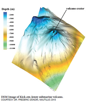
Scientists from the SRC regularly collaborate with other institutions to conduct impactful research on issues of seismic and geologic relevance to our region. Volcanologists at the SRC teamed up with scientists at Imperial College London, Southampton and Liverpool Universities to survey Kick-’em-Jenny immediately following an eruption in April 2017. Using ship-based imaging technology, the team was able to survey the volcano, observing gas coming from the central cone . The data was then combined with previous surveys going back more than 30 years to reveal the long-term pattern of activity. The survey was unique in that it immediately followed an eruption and provided unprecedented data on what Kick-’em-Jenny volcano looks like soon after an eruption. The research, recently published in the journal Geochemistry, Geophysics, Geosystems, provides new insight into the little-studied world of underwater volcanoes.
“The results of this collaborative research project enable us to better quantify our existing model of this volcano and help in developing strategies for managing future eruptions,” noted Director of The UWI SRC, Prof. Richard Robertson.
In addition to conducting research, the UWI SRC currently provides a national seismological and volcanological service for contributing territories in the Eastern Caribbean, as well as support for tsunami warning and public education and awareness on geologic hazards. Although the outcome of Kick-‘em-Jenny’s recent episode remains to be seen – at the time of writing, activity at the volcano had slowed – The UWI SRC is well poised to provide its stakeholders with the necessary information to reduce the risk to lives and livelihoods.
 Kick-’em-Jenny FAQs Kick-’em-Jenny FAQs
How big is Kick-’em-Jenny?
The volcano is about 1300m high, and its summit is currently estimated to be about ~200m below the surface of the sea.
If the volcano erupts will it cause a tsunami?
The threat of a significant tsunami following an eruption of Kick-’em-Jenny is low since it is currently too deep beneath the surface of the sea (~200m). Based on previous eruption patterns scientists do not consider the volcano to currently be a threat to neighbouring coastlines such as St. Vincent & the Grenadines, Barbados or Trinidad & Tobago.
What is an “Alert Level” and what does it mean?
An alert level system is used to quickly inform the public of the state of the volcano. It is set by the civil authorities who are responsible for the territory in which the volcano falls, working in collaboration with monitoring scientists. The National Disaster Management Agency (NaDMA) of Grenada is the agency responsible for changing the alert level for KeJ. Currently, the volcano is most dangerous for ships and boats since the gases constantly being released by KeJ can lower the density of the water causing them to sink even if it is not erupting. For this reason, the alert level for KeJ is always at yellow even if it is not erupting and there is a permanent 1.5km exclusion zone around the summit of the KeJ.
How did Kick-'em-Jenny get its name?
Kick-’em-Jenny is named after a small nearby island called Diamond Rock (or Diamond Islet on some charts). Diamond Rock used to be called Kick-’em-Jenny prior to the discovery of the volcano in 1939. We are not certain of the exact origins of the name ‘Kick-’em-Jenny, but it seems to relate to the fact that the waters in this region are sometimes extremely rough. It may be a corruption of the French: cay que gêne, ‘the turbulent cay (shoal)’, or it may be a reference to a kicking donkey “Jenny”.
|