 In 1960, St. Augustine became the Trinidad campus of The UWI. And in the 58 years that followed, UWI St. Augustine’s growth has been phenomenal – thousands of students, myriad programmes of study, groundbreaking research, and of course, buildings. Like a small society, the campus has grown, and one of the most dramatic signs of its growth is its structures and the assets within them. In 1960, St. Augustine became the Trinidad campus of The UWI. And in the 58 years that followed, UWI St. Augustine’s growth has been phenomenal – thousands of students, myriad programmes of study, groundbreaking research, and of course, buildings. Like a small society, the campus has grown, and one of the most dramatic signs of its growth is its structures and the assets within them.
UWI St. Augustine is made up of offices, lecture rooms, laboratories, commercial spaces, and many other facilities housed in more than a hundred buildings. And for the people responsible for managing and maintaining the campus, access to reliable information on these facilities is critical for informed decision-making. This information, if used strategically, can save the University great amounts of time and money. But first, it must be stored in a structured database that can be easily accessed by decision makers.
Enter the Geospatial Information Research and Innovation (GIRI) Group from the Department of Geomatics Engineering and Land Management (GELM), of the Faculty of Engineering.
“Our campus is a very complex place to manage and good data is crucial to make it work,” says Adam Thomas, a graduate student who is a member of the GIRI Group.
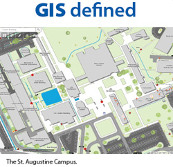
Since 2014, Adam and other members of the GIRI Group have been using a combination of geomatics (traditionally referred to as land surveying), drones, digital cartography and information and communications technology (ICT) to collect and manage data about the campus. This led to the creation of the Interactive Campus Map that is available both on the UWI website (http://sta.uwi.edu/campus-map) and mobile app. The map gives a layout of the campus buildings, other structures, green spaces and even trees.
In 2017, the group embarked on an even more ambitious project.
“The map is a frame of the buildings, a topographic map. Now we are going inside the buildings,” says Anushka Ramnath, an undergraduate geomatics student.
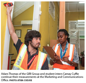
Over the 2017 and current vacation periods, Anushka and a small team of student interns have been going to buildings throughout the campus, measuring rooms and other hard spaces such as permanent cubicles, and drawing building plans that will eventually become part of a Campus Enterprise GIS. This Campus Building Measurement Survey (CBMS) Project, is a partnership between the Office of the Campus Registrar and the GELM Department.
“For a long time we have been doing this kind of work for clients outside of the University, and internally we don’t have the very systems that we have been implementing in other organisations,” says Dr. Earl Edwards, Lecturer in Geoinformatics at GELM.
Dr. Edwards, the mind behind the UWI St. Augustine’s Campus Enterprise GIS project, says: “We have the resources in terms of software and expertise. We have young minds eager to learn. So it’s a win-win situation. The University gets an Enterprise GIS system which can be used for managing its facilities and assets. And the students will be able to play a role where they can work, first-hand, from step one to the final stage of building an Enterprise GIS.”
 One of the most exciting aspects of the project is how pivotal the students have been. Adam and his fellow supervisor, Arrio Lokai, are very much in leadership positions and they are both in their twenties. Most of the fieldwork is carried out by undergraduate students. One of the most exciting aspects of the project is how pivotal the students have been. Adam and his fellow supervisor, Arrio Lokai, are very much in leadership positions and they are both in their twenties. Most of the fieldwork is carried out by undergraduate students.
“Many times we will go to a building and they will say, ‘oh students! Is this an academic project?’” says Adam, smiling. “I tell them no, we are working.”
At 23, he is obviously a very driven young man with clear ideas about the role of GIS in both education and society. “I am going to get into education for sure,” he says. “I love to teach. I also want to be involved with GIS on a national level for decision-making.”
Anushka, 23, from Chaguanas, also enjoys geomatics, particularly the fieldwork, and would like to pursue it further. “Last year (the initial round of building measurements) was my first time working professionally,” she says, highlighting what a valuable experience the internship has been.
Apart from this, there is the benefit of a campus Enterprise GIS. The administration at UWI St. Augustine is aware of the benefits of GIS and is working with GELM through the Office of the Campus Registrar. In fact, Dr. Edwards was initially approached by Asset Manager Keith Chin Pang to collaborate on building on the trove of data collected through the interactive map project.
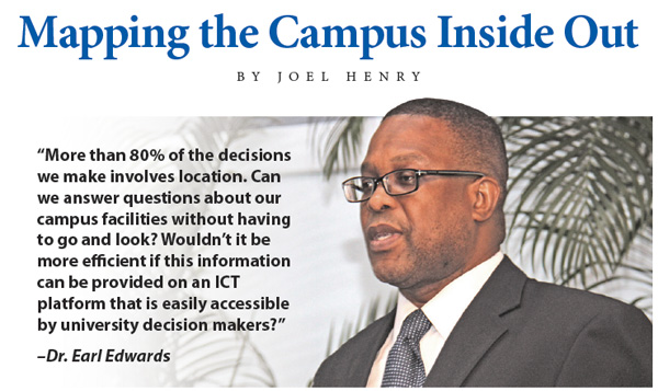
“More than 80% of the decisions we make involves location,” says Dr. Edwards. “Can we answer questions about our campus facilities without having to go and look? Wouldn’t it be more efficient if this information can be provided on an ICT platform that is easily accessible by university decision makers?”
The CBMS project has made good progress but still has some way to go. Interns have collected data and drawn plans for several buildings, including the Faculty of Humanities and Education building and the Alma Jordan Library (which was particularly challenging because of its incremental construction). Campus Administration has given the team a list of priority buildings for measurement and data collection.
The challenge is limited resources, particularly the need for dedicated workers. Currently they only carry out field work during the vacation period. However, they are doing great work and they are confident the results will be just as outstanding.
“I have seen many of these data sets from all over,” says Adam, “and I believe ours will be one of the best ever developed.”
Geospatial Information System (GIS) – integration of information and communication technologies for gathering, managing, analyzing, visualizing and sharing data about our world.
Geomatics Engineering – Traditionally referred to as surveying. Involves the measurement and analysis of data on or near the earth’s surface using tools and techniques such as: drones, GPS, remote sensing, photogrammetry, hydrography, cartography and GIS.
Geoinformatics – the art, science and technology involved with the acquisition, storage, processing production, analysis, presentation and dissemination of GIS data.
UWI St. Augustine’s Department of Geomatics Engineering and Land Management in the Faculty of Engineering, offers a Bachelor of Science degree in Geomatics; Master of Science degree in Geoinformatics and MPhil/PhD degree in Geoinformatics.
|