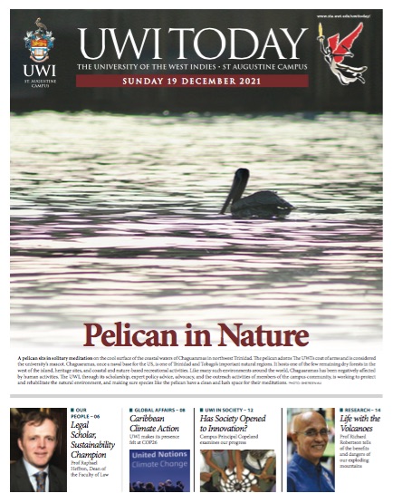
Imagine that you were born and raised on an island in the shadow of a volcano and, when it erupts, you are a teenager and you become inspired. Fast forward 42 years and you are a volcanologist leading a team from The UWI Seismic Research Centre (SRC) to monitor the same volcano, expecting an imminent eruption. What are the odds that you would be a part of the group that would lead the awareness programme and monitoring for citizens, filling a need to have someone familiar with the culture and the region to educate them on what’s happening? Well, those odds worked in Professor Robertson’s favour. In 2020, he was boots on the ground to witness the eruption of La Soufrière himself and help his fellow “Vincys” – the people of St Vincent – in any way he could.
Professor Robertson is not at all new to this. In fact, he has been putting in the work for years, analysing samples and hundreds of years of volcanic historical data for clues as to when the volcano might erupt again. On November 11, he spoke at his professorial inaugural lecture, titled, “Living Safely with Explosive Mountains in the Eastern Caribbean”.
Professor Robertson and his colleagues at UWI SRC have been ready for what they see as the inevitable for any one of the 21 volcanoes that exist within the Caribbean. For many years, they have been building a network within the nine independent territories (from St Kitts and Nevis to Trinidad and Tobago) that they are responsible for and manage. Their research has helped in the production of a Volcanic Hazard Atlas of the Lesser Antilles, that published the colour-coded map of St Vincent which was widely used before, during and after the eruption, clearly denoting relatively safe zones (green and yellow areas) and unsafe zones (red and orange). The atlas provides data for disaster management officials to use, as well as knowledge on volcanic activity that is invaluable before an explosive eruption.
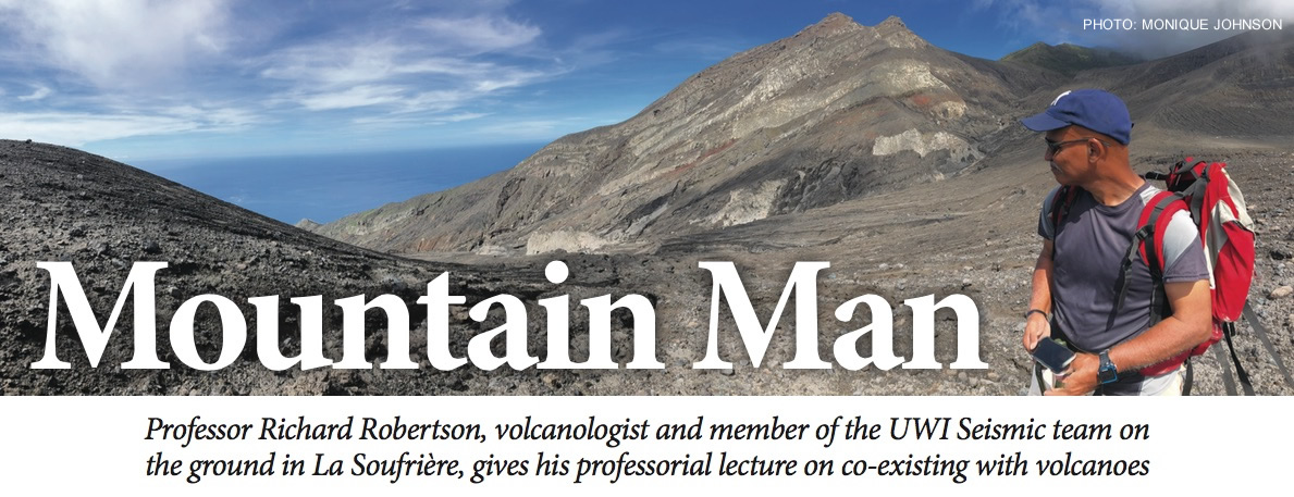
Professor Robertson’s lecture, held virtually, was a wealth of information about Caribbean volcanism. He explained that out of the 21 volcanoes present within the region, six have erupted in the past 400 years; and we should expect both non-eruptive and eruptive activity associated with any of the 21 in the future.
UWI SRC is the official source of information on earthquakes and volcanoes in the English-speaking Eastern Caribbean. They have developed similar volcanic hazard maps for each island, which are based on scenarios of likely future activity – from determination of pyroclastic flows, mudflows or ashfall. This information has been very useful for islands like Barbados, which has been impacted by ashfall from erupting volcanoes although they do not have volcanoes themselves.
“Given the wind direction, once one volcano erupts, it will impact other areas,” said Prof Robertson. “You can’t look at it as something that is affecting your territory alone. Once you deal with volcanic ash, and exploding volcanoes, you must look at it regionally. Ash impact is something that is not fully assessed in the region.”
Professor Robertson also underscored the importance of being able to live sustainably and safely on an island with a volcano or an island that is itself a volcano. Volcanoes bring many benefits to societies, and as such have always attracted human settlement. The fertile earth that develops from volcanic rock and ash tends to result in higher crop yields for farmers. Tourists are attracted to volcanoes, and this creates many job opportunities. Volcanoes also hold significance in many cultural and religious spaces.
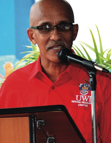
The activities of UWI SRC prior to the 2020-2021 eruption of La Soufrière have laid the groundwork for empowering communities that live within the shadow of a volcano. “A lot of the emphasis we have placed in the last couple of years is engagement with communities,” Professor Robertson explained to the virtual audience, “trying to find ways in which we could make sure that they understand, and they are aware of the hazards that they are living with, and they are empowered to take measures to minimise that impact.” During the La Soufrière eruption, community engagement and the monitoring network that was put into place enabled the early detection of the explosive eruption, and a responsive public when alerted. Most importantly, it saved lives.
He said, “The management of the situation benefited greatly from a lot of the effort that was put in assessing the hazard, and the development of hazard maps which allowed plans to be made and allowed us to do simulations to test those plans, and then also the engagement of the public. All of that came together to a large extent in 2021 with the result that we had.”
Living safely and sustainably with explosive mountains requires the type of consistent monitoring that Prof Robertson and the UWI SRC team has been doing and continues to do. The ongoing efforts to engage policymakers and the push towards enhancing hazard maps and community engagement are one of the many initiatives for the future. Challenges are expected, but the positive outcomes of the management of the 2020-2021 eruption bodes well for islands like St Vincent.
As Professor Robertson said, “We need to live with volcanoes safely and sustainably, but we can’t discount the impact they can have, if and when they erupt.”