|
|
 |
 |
|
June 2018
|
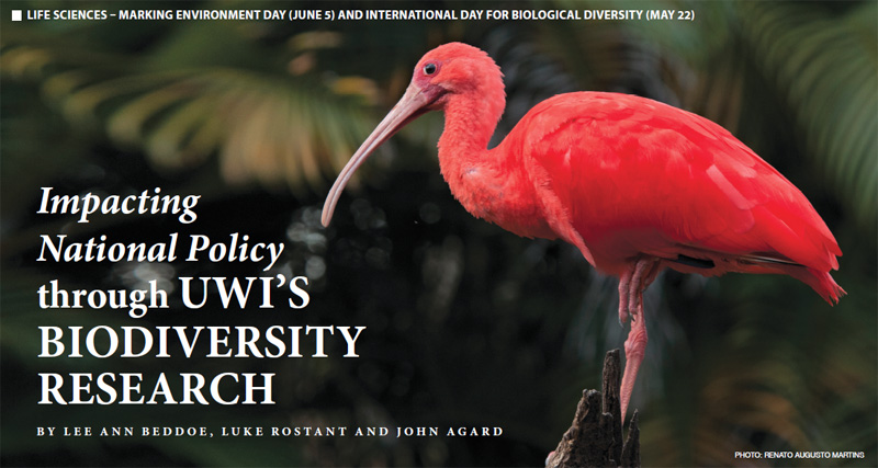
Following intense citizen outrage over poaching of one of the national birds – the Scarlet Ibis (Eudocimus ruber) – a request was made to have it be declared an environmentally sensitive species. The UWI and other stakeholders were invited by the EMA to partner on this policy decision and to help better inform the process. Fortunately for the state, the MSc in Biodiversity Conservation and Sustainable Development in the Caribbean at The UWI, St Augustine had recently concluded a Research and Development Impact Fund project that provided data from several pertinent research projects. Specifically referenced were Deanna Albert’s “Participatory GIS for nesting, roosting and feeding habitat sites of the Scarlet Ibis Eudocimus ruber in Caroni Swamp, Trinidad”; Aditi Thanoo’s “Local community use of the Caroni Swamp: use, attitudes and perceptions”; and Reisha Boodram’s “Public participatory GIS for traditional uses of the Caroni Swamp”. We are pleased to continue to collaborate with our nation’s decision-makers in the pursuit of this designation based on scientific research, participatory GIS (PPGIS), and trends observed. Albert’s research used participation methods alongside Geographic Information Systems (GIS) technology in order to engage a variety of stakeholders, both community participants as well as experts, to map the habitat sites where the Scarlet Ibis nests, roosts and feeds in the Caroni Swamp. After a short orientation on the project objectives, mapping groups were asked to identify areas which the Scarlet Ibis use on an aerial photograph of the Caroni Swamp, using colour-coded stickers for nesting (yellow), roosting (red) and feeding (blue) sites. Additional data were collected on these identified points through semi-structured interviews, asking questions such as numbers observed, habitat characteristics, prey, predators, etc. Assessment of the effectiveness of existing Protected and Prohibited Areas can be done through comparison of identified points against the boundaries of the Forest Reserve, Wildlife Sanctuaries, and RAMSAR Site (Protected Natural Areas – PNAs). Survey data were used to determine the degree of overlap between local and expert knowledge collected through mapping exercises. It is expected that data collected from this project can facilitate better management planning for PNAs within Caroni Swamp and be used as a foundation for further studies focused on the Scarlet Ibis within Caroni Swamp or along its wider habitat extent along the wetlands of the west coast of Trinidad. Thanoo’s research demonstrated that restricting use and access of protected areas can lead to local people holding negative attitudes towards protected areas and violating regulations to illegally use protected areas (Allendorf et al. 2012). Negative attitudes can affect local perceptions of any future policy action and management strategies. In this regard, one way to improve protected area management is to conduct a qualitative study that encourages an understanding of local people’s resource use, attitudes and perceptions, and underlying causative factors (Chandool 2007; Allendorf et al. 2012). Boodram’s study reiterated the importance of the Caroni Swamp as the largest mangrove forest in Trinidad. It provides a range of resources which makes it economically important to local people. Uses of the swamp include recreational activities such as sport fishing, bird watching and photography, and extractive activities include subsistence or commercial fishing, oyster harvesting and crab harvesting (Bacon, 1968; 1993; Juman, Bacon and Gerald, 2002). The Swamp was declared a Ramsar site in 2005 in order to protect its rich biodiversity including many threatened species, and to practice sustainable use of its abundant natural resources (Juman and Ramsewak, 2013). Prior to this, in 1987 a large portion of the swamp, bounded by the Blue River to the north and the Madame Espagnol River to the south, was designated a Prohibited Area in order to protect the country’s national bird Eudocimus ruber (Linnaeus, 1758), the Scarlet Ibis. This ban resulted in a significant decrease in legal resource use within the swamp (Juman, Bacon and Gerald, 2002). The use of local knowledge is important for conservation and sustainable natural resource management. This study used PPGIS to access local knowledge from Felicity residents on resource locations within the Caroni Swamp. Multiple objectives for one defined area can lead to conflict of interest amongst stakeholders and resource extraction outside legal limits. The use of PPGIS is important for visualising hot-spot areas and would be important for in-situ management planning. The designation as an ESS will enhance the protective legal status of the Scarlet Ibis. The fine under this designation will be increased to TT$100,000 and imprisonment for two years. It is anticipated that all of the research from the RDI Caroni Swamp project will be used to inform the future decision to designate the Caroni Swamp an Environmentally Sensitive Area. Enhancing the protective status of the Scarlet Ibis and the area should not be done in isolation. This must be pursued in concert with raising public awareness and sensitisation of the importance of the national bird and other animals within our country. In order to sensitise the public, we need to know what exactly exists in Trinidad and Tobago. So the National Wildlife Survey that is being conducted as a collaborative effort between the EMA and the UWI’s MSc Biodiversity team, funded by the Green Fund under the EMA’s “National Restoration, Carbon Sequestration, Wildlife and Livelihoods Project”, is important. Data collected from the National Wildlife Survey can be used to inform decision-makers in the forging of state policy and management of our national heritage. Websites:
|