|
|
 |
 |
|
September 2019 |
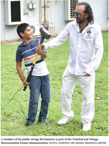
To commemorate this powerful display of nature, UWI’s Seismic Research Centre (SRC) invited the public to two open house tours on the one-year anniversary of the earthquake. The two tours were fully subscribed and the public was taken through the inner workings of the Centre. The SRC staff sought to bust myths and clear any misconceptions people may have about earthquakes, volcanoes and tsunamis. The public was taken along the “Data Trail” as they followed the path from earthquake generation to processing of the event. Earthquake and tsunami information and safety videos produced in-house were shared with the visitors. They also saw a display of research projects conducted by SRC that focused on understanding geological hazards. Attendees were invited to use seismic tomography instrumentation that comprises part of the Trinidad and Tobago Microsonation Project. Dr IIias Papadopoulos, SRC Engineering Seismologist and project lead, explained the process: “It is a digital seismograph, a series of geophones and cables to connect everything. It is triggered by a piesoelectric crystal which is activated when a sledgehammer hits the ground and starts timing. The whole experiment lasts a few milliseconds, as the waves travel at the shallow subsurface and arrive at the geophones. From the data, we can determine the stratigraphy and velocity of the subsurface, which is used to determine the seismic hazard, among other things. It can also be used for fault determination, geotechnical characterisation, karst identification and environmental solutions. The Centre currently employs this technique, among others, at the Banwari Trace as we do forensic Geophysics to help the archaeologists and the National Trust to investigate the area for more artifacts”. The public ended the tour with a viewing of volcanic hazard videos and demonstrations of equipment used to monitor and better understand volcanoes and their associated hazards. |

 It was early evening on August 21, 2018, when Trinidad and Tobago, along with the rest of the Southern Caribbean, experienced the most powerful earthquake in the last 50 years. The shaking was the longest ever experienced (90 seconds).