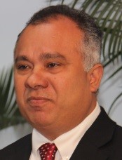
Bheshem Ramlal
Professor and Dean, Faculty of Engineering

The University of the West Indies
St. Augustine
Trinidad and Tobago
Telephone: 868-662-2002
Dr. Bheshem Ramlal is a Professor of Geospatial Information Engineering and Dean, Faculty of Engineering from 1st October, 2023. His research is focused on the development of spatial data infrastructures, geo-enablement of society, data quality issues, data sharing policy, and participatory decision support systems. Professor Ramlal has published several academic and professional papers in journals, books and conferences. He has served as a reviewer for several journals and conferences, and as a member of the organizing committee for several regional and international conferences. He has provided professional support on several geospatial and mapping projects for national, regional and international agencies. He has served in several capacities at the University of the West Indies, on professional bodies and state organizations.
Qualification
- PhD Spatial Information Science and Engineering, University of Maine, Orono, ME, USA
- MSc. Map and Geo-information Production, International Institute for Aerospace Survey and Earth Sciences, Netherlands
- Map and Geo-information Production, International Institute for Aerospace Survey and Earth Sciences, Netherlands
- BSc. Land Surveying, University of the West Indies, St. Augustine, Trinidad and Tobago
- Certificate in Education, Teaching and Learning, University of British Colombia, Vancouver, Canada
Professional Experience
- Expert Member (GIS), Technical Advisory Committee, and Chair, GIS Technical Task Group, Assessing the Vulnerability of Trinidad and Tobago to Climate Change and Sea Level Rise
- Chairman, Board of Directors, National Spatial Data Infrastructure Council of Trinidad and Tobago
- Chairman, National Spatial Data Infrastructure Committee, Government of Trinidad and Tobago. Cabinet Appoint Committee
- Member, Board of Directors, Accreditation Council of Trinidad and Tobago, Ministry of Tertiary Education and Skills Training, Government of Trinidad and Tobago
- GIS Expert Committee Member, Risk Reduction Sub-Committee on Improving Risk Information and Early Warning, Ministry of National Security
- Chair, Study Group 4.4.1 Marine Spatial Data Infrastructure, Commission 4, International Federation of Surveyors (FIG)
- GIS Expert Committee Member, Cabinet Appointed Committee on Hillside Development Policy for Trinidad and Tobago, Ministry of Planning and Sustainable Development, Government of Trinidad and Tobago
- Public Relations Officer and Member of the Executive, Institute of Surveyors of Trinidad and Tobago
- Chair, Continuous Professional Development and Education Committee, Institute of Surveyors of Trinidad and Tobago
- Treasurer, GIS Society of Trinidad and Tobago GIS Advisor, Anglican Church of Trinidad and Tobago
Professional Memberships
- International Geospatial Society
- Royal Institution of Chartered Surveyors
- Institute of Surveyors of Trinidad and Tobago
- GIS Society of Trinidad and Tobago
- Urban and Regional Information Systems Association (URISA)
- URISA, Caribbean Chapter
- Chartered Institution of Civil Engineering Surveyors
Courses Taught
- GEOM 3050 Special Investigative Project
- GEOM 2060 Cartography
- GEOM 2017 Geoinformatics for Civil and Environmental Engineers
- GINF 6021 GIS and Society
- GINF 6030 Independent Study in Geoinformatics
- GLIS 0411 Introduction to GIS/LIS
- GLIS 0421 Cartography and Visualization
- LAND 5004 Land Information Management


