Matura Vegetation Survey
Objectives
- Carry
out a baseline biological survey of the vegetation of the Matura
Natural Park, identifying vegetation types and plant communities
- Identify
potential species of concern
- Evaluate
the extent of degradation of the plant communities identified.
Methods
The vegetation and plant communities of Matura National Park are studied through
plot inventories. Survey sites are chosen through stratified sampling using
GIS layers to account for variability caused by topography, climate, geology,
altitude, slope exposure and human disturbance.
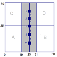
Twenty-four (24) nested 50 m x 50 m permanent sample plots will be established
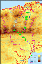
in Matura National Park, along a roughly N-S transect line (trail) connecting
the two main access routes into the park (from Grande Rivière to Salybia).
This trail follows geographical ridges and is set up as a permanent trail for
future monitoring.
Sample plots are positioned in sets of three plots preferably on W-facing slopes:
one plot on the ridge, one in the middle slope, and one at the base of the slope.
Plots are homogeneous in vegetation, excluding disturbances, and away from trails
and streams.
All trees and lianas with diameter 10 cm or above at breast height are tagged
and surveyed. Trees are coded MESA xx-yy-zz, with xx indicating plot number (1
to 24), yy subplot letter (A,B,C,D) and zz tree number; for example MESA 01-A-01.
Within a central 12 x 50 m subplot all trees and lianas with diameter 2.5 – 10
cm are surveyed and tagged. Ground flora and epiphytes are recorded in five 2m
x 2m quadrats positioned along the centre line.
Herbarium specimens are collected for all recorded plants, and identified and
deposited at the National Herbarium of Trinidad.

Team
The survey was coordinated by Alesha Naranjit, Brent Alexander, Veerle Van den Eynden and Mike Oatham
|
| Vegetation
Survey |
 |
 photographs by Laishalla Seeram
 |
|