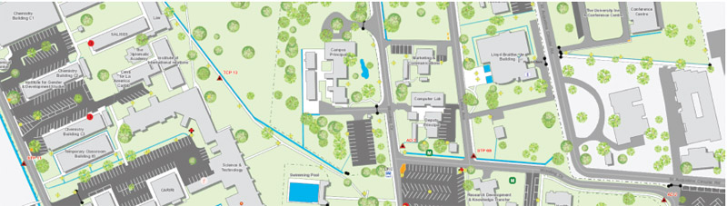
 In 2014, a team of staff and students from the Department of Geomatics Engineering and Land Management within UWI St Augustine’s Faculty of Engineering embarked upon an ambitious project to map the campus and develop a web-based platform for managing and disseminating the information. In 2014, a team of staff and students from the Department of Geomatics Engineering and Land Management within UWI St Augustine’s Faculty of Engineering embarked upon an ambitious project to map the campus and develop a web-based platform for managing and disseminating the information.
Now, the ongoing work of that team, the Geospatial Information Research and Innovation (GIRI) Group, has been recognised for their achievement by the largest organisation in the field of geographic Information systems/science (GIS).
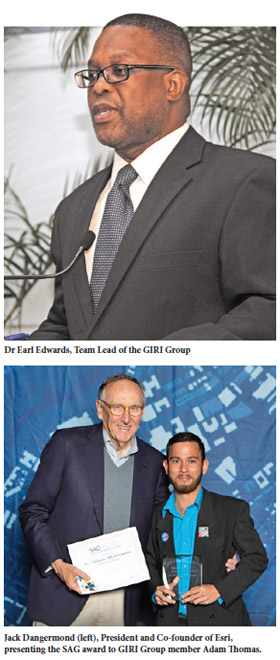
On July 10, 2019, the US-based GIS firm Esri, awarded the group with the Special Achievement in GIS (SAG) Award at their 2019 Esri User Conference in San Diego, California, to recognise their outstanding work implementing GIS technology. Winning a SAG Award means the GIRI Group stood out in a field of more than 100,000 others globally.
Dr Earl Edwards, Lecturer in Geospatial Information Science at UWI and GIRI Group Team Lead, said he felt “elated and extremely pleased” by the award.
“The members of the GIRI Group, both staff and students, have been working hard, donating freely their time towards this noble cause,” Dr Edwards said. “It gives some validation to the opinion that The UWI does not only impart theory, as some may believe, but we can also implement systems to address real world problems that are as good as those created by GIS practitioners in developed countries.”
UWI Today first covered the work of the GIRI Group in its August 2018 issue (see “Mapping the Campus Inside and Out” https://sta.uwi.edu/uwitoday/archive/august_2018/article19.asp). The system developed for UWI St Augustine by the group is referred to as an Enterprise GIS (EGIS). The inclusion of indoor data in the EGIS is extremely rare in the region and this implementation is quite possibly a first for the Caribbean.
“There is this belief that within Trinidad and Tobago we do not have the capacity to implement such geospatial technologies and there is always a reliance on foreign consultants,” Dr Edwards says. “We can save much needed foreign exchange and help build capacity in the region by engaging The UWI to assist with some of these consultancies. This will surely provide an avenue for our students to have the opportunity to work on real world projects and gain valuable experience before entering the world of work.”
The EGIS consisted of four stages. The first was the mapping of the campus using traditional techniques such as field surveying complemented with modern techniques and technologies such as drones and satellite positioning systems. The second phase involved the measuring of internal spaces (rooms) to create floor plans for several campus buildings and a “data model” to store this digital information. Third was the creation of a comprehensive database combining both the buildings and their interiors using GIS software provided by Esri. The fourth phase of the project was to develop applications to, in the words of Dr Edwards, “capture, query, analyse and disseminate GIS data related to the campus”.
One of the goals of the project was to give campus bodies such as the Division of Facilities Management a powerful information tool in planning for and maintaining the campus’ buildings, equipment and other facilities.
“Our campus is a very complex place to manage and good data is crucial to make it work,” Adam Thomas, a member of the GIRI Group and an engineering technician within the Geomatics Department said last year when discussing the project.
Apart from its work on the campus, the GIRI Group has embarked on the “Community of Professional Mappers Initiative”, reaching out to Government agencies to explore innovative ways of creating fundamental GIS datasets. The aim is similar to the campus project - give Government organisations the ability to access the geographic data required to make informed decisions and manage its limited resources utilising GIS technologies.
“We are getting very good responses (from Government agencies),” says Dr Edwards, giving the example of the Penal-Debe Regional Corporation, which has expressed an interest in being the first local government entity to collaborate with the GIRI Group.
Founded in 1969, Esri, or Environmental Systems Research Institute, is the leading international GIS software provider with over 40 per cent of global market share. They supply most of the government and private sector organisations in the region through their distributor, Spatial Innovision Ltd. UWI is the Caribbean’s number one institution for training in GIS and offer programmes at the undergraduate and postgraduate levels
|