
In Trinidad and Tobago, the Piparo Mud Volcano is as multifaceted as the island itself. For some, it is a sacred site where nature’s power and spirituality intertwine, while others see it as a fascinating tourist attraction. Yet for many more, it forms a crucial part of the island’s Carnival traditions, where its mud is worn with pride. However, the Piparo Mud Volcano is also a formidable natural hazard. Beneath this lively cultural symbolism lies a powerful force that demands our attention. The violent eruption in 1997 demonstrated its power, ravaging everything within a one-mile radius, displacing 31 families, claiming livestock, and leaving key infrastructure in ruins (Figure 1). Unlike traditional volcanoes that expel lava, mud volcanoes act as natural vents, emitting fluidised mud and gas to the Earth’s surface or sea floor. These emissions are driven by overpressurized conditions beneath the Earth and can occur gradually or in more sudden bursts, as observed during periods of heightened activity at the Piparo Mud Volcano in 2019 and 2024. These recent events underscore the urgent need for monitoring and improving our understanding of the mud volcano’s structure.
To achieve this, we have used a variety of monitoring techniques across the entire Piparo Mud Volcano study area, including ongoing GPS monitoring to assess ground deformation and movement, drone surveys with 3D LiDAR to monitor surface changes over time, gamma radiation monitoring to measure natural radioactivity levels, and Electrical Resistivity Tomography (ERT) to monitor subsurface structures and fluid distribution. Monitoring wells were also installed and were equipped with advanced gauges and loggers to track surface temperatures, fluid dynamics and pore pressure variations. Additionally, core samples were obtained for testing to understand the composition and structure of the Piparo Mud Volcano. These combined methods provide a comprehensive understanding of both surface and subsurface processes, offering valuable insights into the Piparo Mud Volcano’s behaviour.
Among these methods, ERT stands out as a powerful monitoring tool to explore beneath the Earth’s surface, like an X-ray of the ground, allowing us to see the subsurface structures below without digging. For example, Line 9, seen in Figure 1, was one of 34 ERT survey lines we ran across the Mud Volcano, and it intersected distinct rock units, which included a pressurised mud fluid reservoir in addition to Clayey Siltstones and Silty Claystones (Figure 2, Part A). This is an incredible discovery that we were not only able to image, but also track over time, observing its movement, size, shape and extent of its reach beneath the surface of the Piparo Mud Volcano.
Data from the monitoring wells provided further details of the potentially increasing hazards of a mud eruption. Figure 2, Part B, shows temperature and pressure measurements from the 30-metre deep monitoring well BH3, which is within the pressurised mud fluid reservoir and is part of a network of nine strategically placed monitoring wells within the survey area. The data reveals a direct relationship between pressure and temperature, with pressure consistently increasing within the system over the period during which measurements were taken. The point at which an eruption can happen is not currently known, but by tracking pressure fluctuations, we can determine the threshold needed to trigger an eruption. This data can lay the foundation for developing an early warning system.
This groundbreaking research is the first worldwide to directly measure pressure within an active pressurised mud fluid reservoir, offering unprecedented insight into the internal eruption dynamics. These findings are deepening our understanding of eruption dynamics and also highlight the urgency of expanding this research. Despite the potential effectiveness of this technique, its long-term success and scalability require further in-depth investigation. To extend this pioneering research to all 32 mud volcanoes in Trinidad, financial support is crucial. Without resources, the opportunity to mitigate eruption risks could be lost, leaving communities vulnerable. With funding, we can enhance our ability to monitor, predict, and mitigate eruption risks. These findings will feed into risk assessment and delineation of hazard zonation maps for at-risk communities.
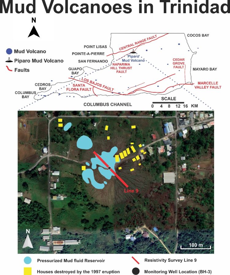
Figure 1. Map of southern Trinidad showing mud volcanoes and major faults. The bottom map of Piparo Mud Volcano shows the pressurised mud fluid reservoir, houses destroyed in the 1997 eruption, Resistivity Survey Line 9 and monitoring well BH-3
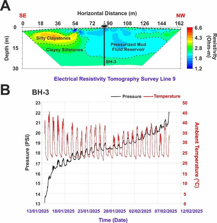
Figure 2 (A) Electrical Resistivity Tomography Survey Line 9. (B) Pressure and ambient temperature measurements as a trend of time

Professor Oshaine Blake
Prof Oshaine Blake is a Professor of Geomechanics and Geophysics at The UWI, St Augustine Campus. He has built three world-class research facilities at the St Augustine Campus